LandTracker Maps: Tracking tenement boundaries in Google Maps and GPS for free
Prospectors, geologists, farmers, and environmentalists have a common need to access up to date mining tenement boundaries. This information varies from state to state, is inconvenient to download and update, and is often locked up in formats that need expensive GIS (Geographic Information System) Software to access.
LandTrack Systems have been collecting tenement data from across Australia for a number of years for its land use tracking tools. Recognising the broad communities need for a simple way to see up-to-date tenement boundaries, they decided to make it freely available as an extension to Google Maps, called “LandTracker Maps”.
Justin von Perger, Managing Director of LandTrack Systems explains:
“There is a broad need and interest in seeing the extent of mining licenses across Australia, but no simple way to access it. Farmers and local groups are keen to identify any new applications on their land, and people in the field need to view up-to-date tenement boundaries quickly and easily on their GPS device so they know exactly whose land they are on!”
“We have been collecting this information for quite some time and it’s too good to lock up. I decided to produce a free App which would allow people to view and download tenements anywhere in Australia on any GPS device, without needing expensive GIS Software.”
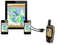
LandTracker Maps has been specifically designed to work on any mobile device or desktop. It enables landholders on the move and in the field to navigate across any of their tenements easily using any GPS device. It also provides a graphical view of the relationships of each tenement and all surrounding tenements.
Best of all, the boundaries are updated every morning from every State Government Mines Department across Australia, ensuring that they are always as accurate as possible. LandTracker Maps is a revolutionary new app that frees your tenements from the chains of archaic GIS systems.
LandTrack System has been serving the mining industry for nearly 10 years with its innovative, specialised software tools that simplify land acquisition and land management.